Converts Earth-Centered-Earth-Fixed (ECEF) to latitude and longitude
This function converts the Earth-Centered-Earth-Fixed (ECEF) coordinates to altitude, latitude and longitude. To calculate, enter x, y and z in metres. Then click the 'Calculate' button.
|
Angle north and south of the equator. Positive angles are in the northern hemisphere and negative angles are in the southern hemisphere. The angular range is -90 degrees (-π/2 radians) to +90 degrees (+π/2 radians). Points on the equator have zero latitude.
Angles east and west of the Prime Meridian. The prime meridian is a north-south line that runs through Greenwich, United Kingdom. Positive longitudes are east of the Prime Meridian and negative angles are west. The angular range is from -180 degrees (-π radians) to +180 degrees (+π radians).
Height above the earth's ellipsoid measured in meters. The earth's ellipsoid is a surface which is defined by a semi-major axis and a semi-minor axis. A geodetic altitude of zero corresponds to the mean sea level, where positive values increase away from the center of the earth. The theoretical range of altitude values extends from the center of the earth (approx. -6,371 km) to positive infinity.
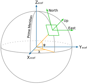
ECEF is a right-hand Cartesian coordinate system with the origin at the center of the earth. Units are in meters.
X runs through the equator at the prime meridian (latitude = 0, longitude = 0).
Y passes through the equator 90 degrees east of the prime meridian (latitude = 0, longitude = 90 degrees).
Z passes through the North Pole (latitude = 90 degrees, longitude = any value).
|
|